
The young scientists of the world have proven themselves truly impressive people—inventing technologies to improve the accuracy of prosthetic devices, developing video-audio memory aids for dementia patients and improving switch designs to prevent train derailments. These are just three of the top 15 projects competing for the grand prize in the inaugural Google Science Fair final tonight, which we’ll be live streaming at 7pm PDT at youtube.com/googlesciencefair.
Back in January, we launched the first Google Science Fair in partnership with CERN, LEGO, National Geographic and Scientific American. We asked young people from ages 13-18 all over the world to submit projects online that were creative, inspiring and groundbreaking. Ten thousand students from 91 countries submitted 7,500 projects, from which our international team of judges selected the top 15 finalists.
Today, those finalists are at Google headquarters in Mountain View, Calif. where they’ll present their projects to a panel of science luminaries, inventors and Nobel laureates. The winners will receive amazing prizes including $100,000 in scholarships, internships at Google or our partners and a National Geographic Expedition to the Galápagos Islands.
So pull up a chair in your home laboratory and tune in to a live stream of the first Google Science Fair to find out which budding young Einstein will take home the grand prize. The event begins tonight, Monday July 11, at 7pm PDT—watch at youtube.com/googlesciencefair.
About Me
Monday, July 11, 2011

The first Google eBooks-integrated e-reader: iriver Story HD
(Cross-posted from the Inside Google Books Blog and the Google Commerce blog)
Starting this coming Sunday, July 17, the iriver Story HD e-reader will be available for sale in Target stores nationwide and on Target.com. The iriver Story HD is the first e-reader integrated with the open Google eBooks platform, through which you can buy and read Google eBooks over Wi-Fi.

The iriver Story HD, which retails for $139.99, is slim and lightweight with a high-resolution E Ink screen and a QWERTY keyboard for easy searching. It includes over-the-air access to hundreds of thousands of Google eBooks for sale and more than 3 million for free. With the Story HD you can now browse, buy and read Google eBooks with your e-reader through Wi-Fi, rather than downloading and transferring them from computer to e-reader with a cord as you can already do with more than 80 compatible devices.
We built the Google eBooks platform to be open to all publishers, retailers and manufacturers. Manufacturers like iriver can use Google Books APIs and services to connect their devices to the full Google eBooks catalog for out-of-the-box access to a complete ebookstore. You can also store your personal ebooks library in the cloud—picking up where you left off in any ebook you’re reading as you move from laptop to smartphone to e-reader to tablet.
In December, Google eBooks launched with the ability to read Google eBooks on any device with a modern browser, on Android and iOS devices using the Google Books mobile apps, through our Chrome Web Store app and on compatible ereaders. Since then, we’ve added new retailers—growing to include more than 250 independent bookstores—and made Google eBooks available in Android Market. We’ve also extended our affiliate network and updated our family of Google Books APIs.
The Story HD is a new milestone for us, as iriver becomes the first manufacturer to launch an e-reader integrated with Google eBooks. You can learn more about the Story HD on the iriver website.
Stay tuned for more Google eBooks-integrated devices to come. If you’re a manufacturer interested in integrating your next device with the Google eBooks e-commerce platform, please contact us at books-devices-request@google.com.
Update 7/13: We've corrected the word "e-ink" to the more precise "E Ink" as that is the technology brand used in the device's high resolution screen.
Starting this coming Sunday, July 17, the iriver Story HD e-reader will be available for sale in Target stores nationwide and on Target.com. The iriver Story HD is the first e-reader integrated with the open Google eBooks platform, through which you can buy and read Google eBooks over Wi-Fi.

The iriver Story HD, which retails for $139.99, is slim and lightweight with a high-resolution E Ink screen and a QWERTY keyboard for easy searching. It includes over-the-air access to hundreds of thousands of Google eBooks for sale and more than 3 million for free. With the Story HD you can now browse, buy and read Google eBooks with your e-reader through Wi-Fi, rather than downloading and transferring them from computer to e-reader with a cord as you can already do with more than 80 compatible devices.
We built the Google eBooks platform to be open to all publishers, retailers and manufacturers. Manufacturers like iriver can use Google Books APIs and services to connect their devices to the full Google eBooks catalog for out-of-the-box access to a complete ebookstore. You can also store your personal ebooks library in the cloud—picking up where you left off in any ebook you’re reading as you move from laptop to smartphone to e-reader to tablet.
In December, Google eBooks launched with the ability to read Google eBooks on any device with a modern browser, on Android and iOS devices using the Google Books mobile apps, through our Chrome Web Store app and on compatible ereaders. Since then, we’ve added new retailers—growing to include more than 250 independent bookstores—and made Google eBooks available in Android Market. We’ve also extended our affiliate network and updated our family of Google Books APIs.
The Story HD is a new milestone for us, as iriver becomes the first manufacturer to launch an e-reader integrated with Google eBooks. You can learn more about the Story HD on the iriver website.
Stay tuned for more Google eBooks-integrated devices to come. If you’re a manufacturer interested in integrating your next device with the Google eBooks e-commerce platform, please contact us at books-devices-request@google.com.
Update 7/13: We've corrected the word "e-ink" to the more precise "E Ink" as that is the technology brand used in the device's high resolution screen.
Thursday, July 7, 2011
Seeking the Americas’ brightest young minds for a spot at Zeitgeist Americas 2011
This year, we’re mixing up our annual Zeitgeist conferences with the launch of Young Minds, a competition hosted by youth engagement agency Livity, supported by Google and hosted on YouTube. Starting this week, we’re searching for 12 inspirational young people who are making an impact on their world to attend Zeitgeist Americas 2011—our annual gathering of 400+ businesses and thought leaders from across the continent held each year in Paradise Valley, Ariz.
The winners will be invited to the two-day event, where they’ll take part in a series of tailored master classes hosted by Google and meet some of the most powerful and thought-provoking people on the planet. We want the pioneers, changemakers and leaders of tomorrow to take their place alongside the greatest minds of today and use Zeitgeist as a springboard from which they can continue to do amazing things to make the world a better place.
The Young Minds competition is open to people aged 18-24 from the U.S., Canada, Mexico, Brazil, and Argentina. For your chance to win a slot at Zeitgeist Americas 2011, go to www.zeitgeistyoungminds.com before August 25 and upload a video that shows us how you’re making a positive impact on the world.
Update 7/8: Although previously stated that this competition was open to all of the Americas, please note that it is only open to people from the U.S., Canada, Mexico, Brazil and Argentina.
The winners will be invited to the two-day event, where they’ll take part in a series of tailored master classes hosted by Google and meet some of the most powerful and thought-provoking people on the planet. We want the pioneers, changemakers and leaders of tomorrow to take their place alongside the greatest minds of today and use Zeitgeist as a springboard from which they can continue to do amazing things to make the world a better place.
The Young Minds competition is open to people aged 18-24 from the U.S., Canada, Mexico, Brazil, and Argentina. For your chance to win a slot at Zeitgeist Americas 2011, go to www.zeitgeistyoungminds.com before August 25 and upload a video that shows us how you’re making a positive impact on the world.
Update 7/8: Although previously stated that this competition was open to all of the Americas, please note that it is only open to people from the U.S., Canada, Mexico, Brazil and Argentina.
“Download map area” added to Labs in Google Maps for Android
(Cross-posted from the Mobile and Lat Long Blogs)
One way we bring you new product features is through Google Labs—a collection of fun, experimental features you can turn on if you’re interested in the functionality. In fact, Google Maps itself started as a lab. In addition to our desktop Maps Labs, Google Maps for Android has a few tricks you can try out right from your phone. We’d like to introduce you to one new experimental feature, “Download map area," but also remind you of two other ones we already have: “Scale bar” and “Measure.”
Download map area
When you’re visiting an unfamiliar location, Google Maps for mobile is great for getting an idea of how close you are to your destination, where streets and landmarks are in relation to each other, or just for getting “un-lost.” But what if you don’t have a data signal, or you’re abroad and don’t have a data plan? We say that if you use Google Maps for mobile, you’ll never need to carry a paper map again. The “Download map area” lab in Google Maps 5.7 for Android is a step in making that statement true even when you’re offline.
Let’s say later you’re visiting Bordeaux during a trip to France. If you were to open Google Maps for mobile and zoom into Bordeaux without data coverage or wifi, you’d see the image on the left:
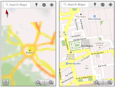
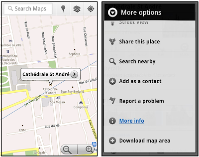
That’s not particularly useful when you’re trying to find out how close you are to the Cathedrale St. Andre. But a little advance planning and “Download map area” can help. Before you take your trip, while you still have access to WiFi or data coverage, you can open up any Places page in the world, click “More” to get the Place page menu, and download Google’s maps for a 10-mile radius.
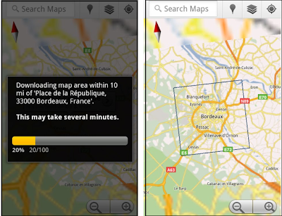
The download can take as little as a minute or two. This download stores only the base map tiles and the landmarks on the map, so you still need a data connection to see satellite view and 3D buildings, search for Places and get directions. But we hope the level of detail available will help you find your way!
All your downloaded map areas can be managed in your Google Maps cache settings so you can delete maps you no longer need or if you want to free up storage. After 30 days, all downloaded map areas will be removed from your cache; they can be re-downloaded any time.
Scale bar
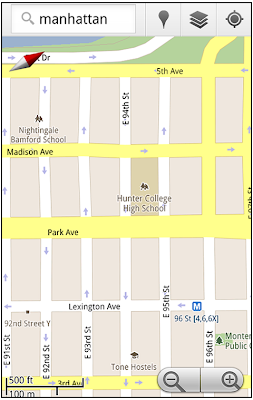
Google Maps has approximately 20 different zoom levels that range from a 2,000 mile scale to a 20 foot scale. With finger gestures making it really quick and easy to zoom in and out, sometimes it’s not always clear what zoom level you’re at. What might be just a few streets away can be quite a long walk depending on the scale. To help with this, you can turn on a scale bar, which updates based on your zoom level.
Measure
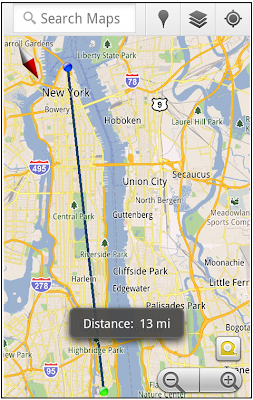
If you ever need to know the distance between San Francisco and New York (about 2602 miles) or between any other two points on the map, the “Measure” lab can help you out. Once it’s enabled, you’ll notice a tape measure icon just above the zoom buttons. After clicking that icon, you’ll be prompted to tap two points on the map and Google Maps will calculate the straight distance between those points (this direct distance is “as the crow flies”).
To access Labs on your phone, press your phone’s menu button once in Google Maps, choose “More” and select Labs. On a tablet, click the menu button in the upper-right corner of Maps. The “Download map area” lab requires Android 2.1+ and the latest version of Google Maps. We look forward to bringing you more experimental features soon and hope you enjoy trying out Labs in Google Maps for Android.
One way we bring you new product features is through Google Labs—a collection of fun, experimental features you can turn on if you’re interested in the functionality. In fact, Google Maps itself started as a lab. In addition to our desktop Maps Labs, Google Maps for Android has a few tricks you can try out right from your phone. We’d like to introduce you to one new experimental feature, “Download map area," but also remind you of two other ones we already have: “Scale bar” and “Measure.”
Download map area
When you’re visiting an unfamiliar location, Google Maps for mobile is great for getting an idea of how close you are to your destination, where streets and landmarks are in relation to each other, or just for getting “un-lost.” But what if you don’t have a data signal, or you’re abroad and don’t have a data plan? We say that if you use Google Maps for mobile, you’ll never need to carry a paper map again. The “Download map area” lab in Google Maps 5.7 for Android is a step in making that statement true even when you’re offline.
Let’s say later you’re visiting Bordeaux during a trip to France. If you were to open Google Maps for mobile and zoom into Bordeaux without data coverage or wifi, you’d see the image on the left:
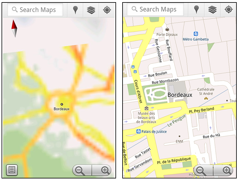
Left: Bordeaux with no data or wifi. Right: Bordeaux with downloaded map area
That’s not particularly useful when you’re trying to find out how close you are to the Cathedrale St. Andre. But a little advance planning and “Download map area” can help. Before you take your trip, while you still have access to WiFi or data coverage, you can open up any Places page in the world, click “More” to get the Place page menu, and download Google’s maps for a 10-mile radius.
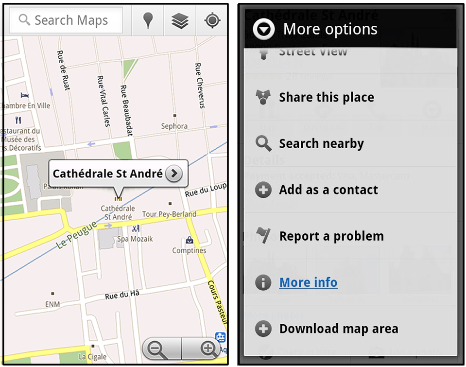
Left: Tap a landmark to enter its Place page. Right: Place page “more options” menu
The download can take as little as a minute or two. This download stores only the base map tiles and the landmarks on the map, so you still need a data connection to see satellite view and 3D buildings, search for Places and get directions. But we hope the level of detail available will help you find your way!

Left: Status screen for download. Right: Coverage of downloaded map area
All your downloaded map areas can be managed in your Google Maps cache settings so you can delete maps you no longer need or if you want to free up storage. After 30 days, all downloaded map areas will be removed from your cache; they can be re-downloaded any time.
Scale bar
Google Maps has approximately 20 different zoom levels that range from a 2,000 mile scale to a 20 foot scale. With finger gestures making it really quick and easy to zoom in and out, sometimes it’s not always clear what zoom level you’re at. What might be just a few streets away can be quite a long walk depending on the scale. To help with this, you can turn on a scale bar, which updates based on your zoom level.

Scale bar in the lower left
Measure
If you ever need to know the distance between San Francisco and New York (about 2602 miles) or between any other two points on the map, the “Measure” lab can help you out. Once it’s enabled, you’ll notice a tape measure icon just above the zoom buttons. After clicking that icon, you’ll be prompted to tap two points on the map and Google Maps will calculate the straight distance between those points (this direct distance is “as the crow flies”).
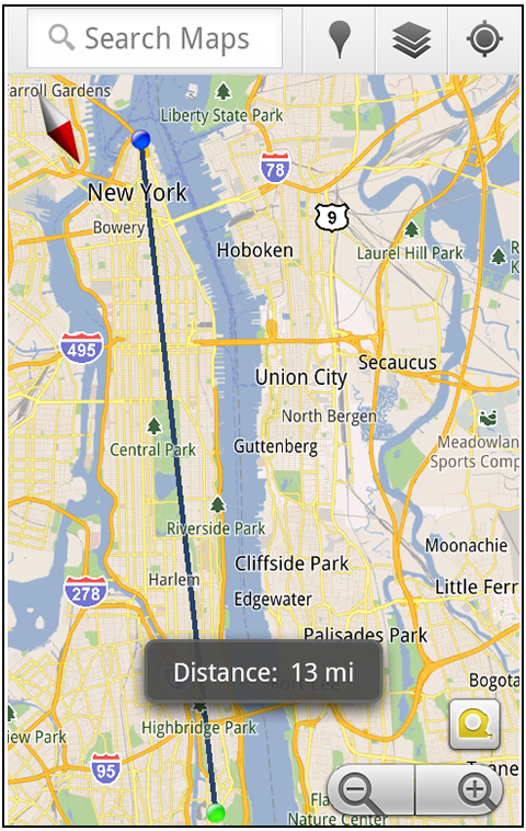
Example of the “Measure” Labs feature
To access Labs on your phone, press your phone’s menu button once in Google Maps, choose “More” and select Labs. On a tablet, click the menu button in the upper-right corner of Maps. The “Download map area” lab requires Android 2.1+ and the latest version of Google Maps. We look forward to bringing you more experimental features soon and hope you enjoy trying out Labs in Google Maps for Android.
Wednesday, July 6, 2011
Google Maps 5.7 for Android introduces Transit Navigation (Beta) and more
(Cross-posted on the Google Lat Long Blog and the Google Mobile Blog)
Today we’re releasing Google Maps 5.7 for Android. From Bangkok to Baltimore, we’ve added Transit Navigation (Beta), updated access to directions, better suggested search results and a photo viewer to Place pages—all of which can help you whether you’re traveling to an unfamiliar part of town or visiting a city across the world.
Transit Navigation (Beta)
Google Maps Navigation (Beta) currently provides over 12 billion miles of GPS-guided driving and walking directions per year. Now, GPS turn-by-turn (or in this case, stop-by-stop) navigation is available for public transit directions in 400+ cities around the globe with Transit Navigation.
Transit Navigation uses GPS to determine your current location along your route and alerts you when it’s time to get off or make a transfer. This is particularly helpful if you’re in a city where you don’t speak the language and can’t read the route maps or understand the announcements. After starting your trip with Transit Navigation, you can open another application or put your phone away entirely and Google Maps will still display an alert in your notification bar and vibrate your phone when your stop is coming up.
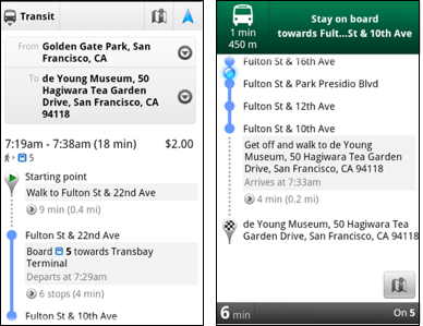
Left: Transit directions without Navigation. Right: with Navigation
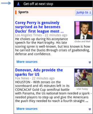
Navigation alerts appear even if you switch to another app
Now you can spend more time enjoying the sights out the window and less time worrying about how many stops are left, where you are along the route or whether you missed your stop. Since Transit Navigation relies on GPS signals, we recommend using this feature for above-ground transit.
Updated Directions
Now that we’ve improved our directions services, we wanted them to be incredibly easy to pull up on your screen. If you select the driving or walking icon and your route is supported by Google Maps Navigation, the Navigation icon will automatically appear so you can get access to step-by-step directions in one click. Note: this change is currently only in place for driving and walking and does not appear for public transit.
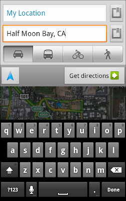
One-click access to Navigation from directions
We’ve also streamlined how you access directions from within a Place page. Before, clicking directions in a Place page would bring up options for “Driving Navigation,” “Walking Navigation” and “Directions.” Now, you’ll be taken straight to the map and see the new directions box shown above.
Improved Search Suggest
We’ve made two changes to search suggestions that improve their quality and speed. First, we’ve added category icons, so instead of all search suggestions displaying the same icon, the icon next to the listing will reflect the type of result. You’ll see a pin for a Google Places listing, a star for a starred Place or location, a clock for a previously used search term, a person for contacts and a magnifying glass for “anything else.”
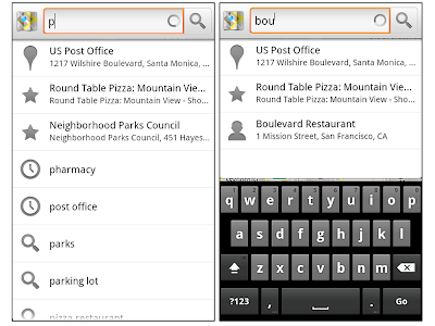
Two examples of search suggest with new icons
Also, any place you got directions to or called directly from its Places page will be included as a suggestion for a relevant search. For example, if you recently received directions to the U.S. Post Office on Wilshire Boulevard, afterward, when you begin a search with [p] or [bou], that U.S. Post Office would appear as a search suggestion.
Photo viewer for Place pages
Since we released business photos for Place pages last October, millions of photos have been added to Place pages around the world. To enable you to view these photos on the run, a slick new photo viewer has been added so you can browse photos while deciding where to go.

Left: Business photos in Place pages. Right: New photo viewer
To start using Google Maps 5.7 for Android, download the update here. This update requires an Android OS 2.1+ device and works anywhere Google Maps is currently available. Learn more at our help center and have fun exploring, whether it be by car, transit, bike or foot.
Today we’re releasing Google Maps 5.7 for Android. From Bangkok to Baltimore, we’ve added Transit Navigation (Beta), updated access to directions, better suggested search results and a photo viewer to Place pages—all of which can help you whether you’re traveling to an unfamiliar part of town or visiting a city across the world.
Transit Navigation (Beta)
Google Maps Navigation (Beta) currently provides over 12 billion miles of GPS-guided driving and walking directions per year. Now, GPS turn-by-turn (or in this case, stop-by-stop) navigation is available for public transit directions in 400+ cities around the globe with Transit Navigation.
Transit Navigation uses GPS to determine your current location along your route and alerts you when it’s time to get off or make a transfer. This is particularly helpful if you’re in a city where you don’t speak the language and can’t read the route maps or understand the announcements. After starting your trip with Transit Navigation, you can open another application or put your phone away entirely and Google Maps will still display an alert in your notification bar and vibrate your phone when your stop is coming up.
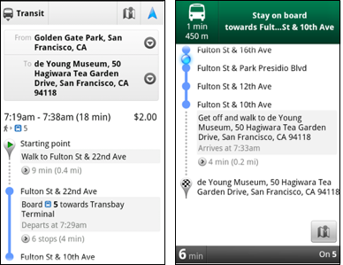

Now you can spend more time enjoying the sights out the window and less time worrying about how many stops are left, where you are along the route or whether you missed your stop. Since Transit Navigation relies on GPS signals, we recommend using this feature for above-ground transit.
Updated Directions
Now that we’ve improved our directions services, we wanted them to be incredibly easy to pull up on your screen. If you select the driving or walking icon and your route is supported by Google Maps Navigation, the Navigation icon will automatically appear so you can get access to step-by-step directions in one click. Note: this change is currently only in place for driving and walking and does not appear for public transit.

We’ve also streamlined how you access directions from within a Place page. Before, clicking directions in a Place page would bring up options for “Driving Navigation,” “Walking Navigation” and “Directions.” Now, you’ll be taken straight to the map and see the new directions box shown above.
Improved Search Suggest
We’ve made two changes to search suggestions that improve their quality and speed. First, we’ve added category icons, so instead of all search suggestions displaying the same icon, the icon next to the listing will reflect the type of result. You’ll see a pin for a Google Places listing, a star for a starred Place or location, a clock for a previously used search term, a person for contacts and a magnifying glass for “anything else.”

Also, any place you got directions to or called directly from its Places page will be included as a suggestion for a relevant search. For example, if you recently received directions to the U.S. Post Office on Wilshire Boulevard, afterward, when you begin a search with [p] or [bou], that U.S. Post Office would appear as a search suggestion.
Photo viewer for Place pages
Since we released business photos for Place pages last October, millions of photos have been added to Place pages around the world. To enable you to view these photos on the run, a slick new photo viewer has been added so you can browse photos while deciding where to go.

To start using Google Maps 5.7 for Android, download the update here. This update requires an Android OS 2.1+ device and works anywhere Google Maps is currently available. Learn more at our help center and have fun exploring, whether it be by car, transit, bike or foot.
Subscribe to:
Posts (Atom)
